COVID-19

City leaders are actively monitoring the COVID-19 pandemic, working closely with the Riverside County Department of Public Health and other agencies. The lead national agency is the Federal Government, which is working closely with the Centers for Disease Control and Prevention (CDC). The lead local agency for this public health matter is the Riverside County Department of Public Health.
COVID Testing in Jurupa Valley
Four free at-home test kits are available to all households. Order ship in 7-12 days, and give results within 30 minutes. Order COVID-19 tests here.
Vaccine Information
Find a vaccination site near you
General Resources
Dial 2-1-1 for County of Riverside COVID-19 Information
Business Resources
Federal
State
Regional & Local
Employee Resources
The lead agency in California for workers dealing with COVID-19 related illnesses or employment impacts is the California Economic Development Department (EDD). Workers are encouraged to utilize the EDD’s online tools for fast and convenient services. We’ve also provided some more specific resources below depending on the current situation that a worker may be dealing with.
Sick or Quarantined
Reduced Work Hours
Layoff or Furlough
General & Other Resources
 (JPG, 137KB)
Community-Based G.I.S. Open Business Map
In response to directives from both Federal and State agencies, many restaurants have started to provide take-out, drive-through, or delivery only services. By working with the Jurupa Valley Chamber of Commerce, the City of Jurupa Valley can provide a map of restaurants in the community that remain open for business.
If you are an owner, manager, or designated representative of a restaurant here in Jurupa Valley and would like your restaurant information to be part of this map, you can access the Open Business Map here. Once you’ve opened the map, navigate to the "Business Hours Form" button at the top of the screen. Please be sure to fill out every line in the form to the best of your ability. You’ll have to enter your address on the form twice and find your address on the map. Staff will then review your submission and approve it to become part of the map. Please contact us if you need help with this process.
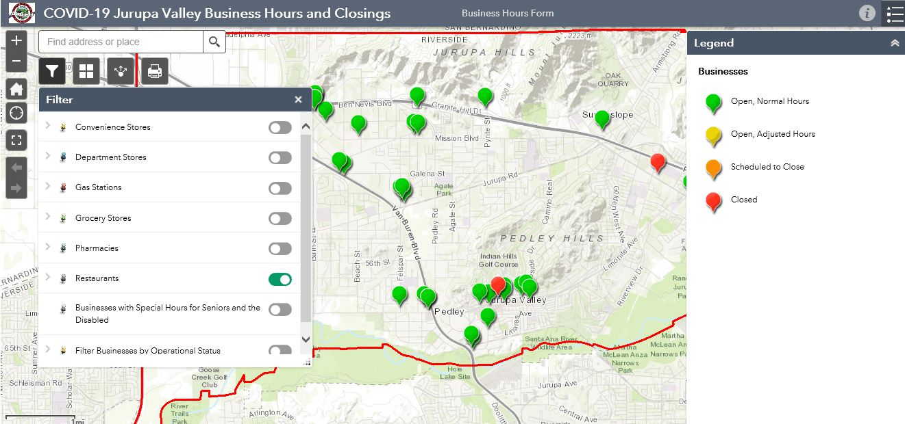
How Was This Map Made?
This map was made by the City’s Geographic Information Systems ("G.I.S.) team. G.I.S. is a database system that can be displayed as a map. If you’ve ever used Google Maps, Apple Maps, or the G.P.S. in your car, you’ve already used a G.I.S. The City uses a G.I.S. program called ArcGIS, which is a product of Esri - a technology company based in Redlands, California. The City uses G.I.S. to inventory infrastructure like roadways, flood plains, zoning and land use, sidewalks, traffic signals, stop signs, and other objects that the City is responsible for maintaining. To access more G.I.S. maps, please visit the City’s G.I.S. page.